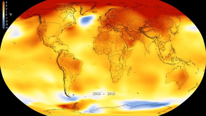
The most probable outcome for the global climate in 2019 is that it will be one of the warmest years ever recorded in human history. That is not a shocking unexpected prediction, but instead comes via looking backwards, observing the ongoing warming trend, and so the probability of this being correct is rather strong.
Today I have a couple of items that point forwards, so let’s briefly look at each in turn.
1. UK Met Office Forecast
On 6th February 2019 they issued a forecast that suggested that the next 5 years will be the warmest 5 years ever recorded. Here is what they have …
Professor Adam Scaife, Head of Long-Range Prediction at the Met Office said: “2015 was the first year that global annual average surface temperatures reached 1.0 °C above pre-industrial levels and the following three years have all remained close to this level. The global average temperature between now and 2023 is predicted to remain high, potentially making the decade from 2014 the warmest in more than 150 years of records.”
Averaged over the five-year period 2019-2023, forecast patterns suggest enhanced warming is likely over much of the globe, especially over land and at high northern latitudes, particularly the Arctic region.
Figure 1: The blue envelope indicates the likely range of temperatures for the period 2019 to 2023. The black line represents the observations and the red area indicates previous forecasts.
Dr Doug Smith, Met Office Research Fellow said, “A run of temperatures of 1.0 °C or above would increase the risk of a temporary excursion above the threshold of 1.5 °C above pre-industrial levels. Predictions now suggest around a 10 per cent chance of at least one year between 2019 and 2023 temporarily exceeding 1.5 °C.”
Alongside this forecast, 2018 is today cited to be nominally the fourth warmest year on record globally in data released by the Met Office, at 0.91±0.1°C above the long-term pre-industrial average. It follows 2015, 2016 and 2017, which are the three warmest years in the 169-year record of the HadCRUT4 dataset.
Professor Tim Osborn, director of the University of East Anglia’s Climatic Research Unit, which co-produces the HadCRUT4 global temperature figures with the Met Office Hadley Centre, said: “The warmth of 2018 is in line with the long-term warming trend driven by the world’s emissions of greenhouse gases.”
The effects of climate change are not limited to surface temperature. Warming of the climate system is seen across a range of climate indicators that build a picture of global changes occurring across the land, atmosphere, oceans and ice.
The Met Office decadal forecast show that global average surface temperatures may be close to reaching 1.5 °C, but this would be a temporary exceedance rather than the climatological level of warming in the Paris 1.5 °C threshold.
Cue some GOP pundits claiming that the UK Met Office are just in it for the money.
Er no, they are not a private organization, they are part of the UK government’s Department for Business, Energy and Industrial Strategy. They get paid and funded regardless of what they predict. Their only motive is to be as reliable and as accurate as possible.
OK, on to the second of my two forward looking items.
2. El Nino is back
When El Nino arrives, it brings with it a disruption of the normal global weather patterns.
NOAA monitors it all. On 14th February 2019 they issued the following …
February 2019 ENSO Update: El Niño conditions are here
… What’s new over the past month is that we’re seeing signs of El Niño-related changes in the atmosphere, with increased clouds and rain in the central Pacific indicating a weaker Walker circulation. One measurement of the strength of the Walker circulation, the Equatorial Southern Oscillation Index, was -0.6 during January, indicating more rising air than average over the eastern Pacific, and less than average over the western Pacific. These changes are enough evidence that the atmosphere is responding to the warmer ocean, leading us to conclude we have El Niño conditions!…
… The future remains to be seen, but forecasters give weak El Niño conditions the edge through the spring. After that, chances of a continued El Niño drop below 50%. It’s tough to make a successful forecast for later in the year, due in large part to the “spring predictability barrier,” a notoriously tricky obstacle for computer models. Spring is a time of year when ENSO (El Niño/Southern Oscillation, the entire El Niño and La Niña system) is often transitioning, making it especially difficult to predict what comes next….
Further Reading: It’s official: El Niño is back. Now what? …
…The advent of this El Niño means that 2019 is “almost certain to be another top-5 year,” wrote Gavin Schmidt director of the NASA Goddard Institute for Space Studies, in an email to Grist. He gave “roughly 1-in-3 odds” that 2019 will surpass 2016 as the warmest year on record, thanks in part to the boost from El Niño….
The last one in 2015-16 amplified global warming and resulted in record breaking global temperatures, and so here it is once more. It’s back.
What will 2019 bring?
Ignore the idiot-in-chief who thinks it is all a Chinese hoax and pay attention to the subject matter experts who devote their entire careers to truly understanding what is going on.
Global Warming is here and it is not going to go away magically, but instead things are only going to get worse.
Decisive meaningful action is needed, doing nothing is really not an option.
