
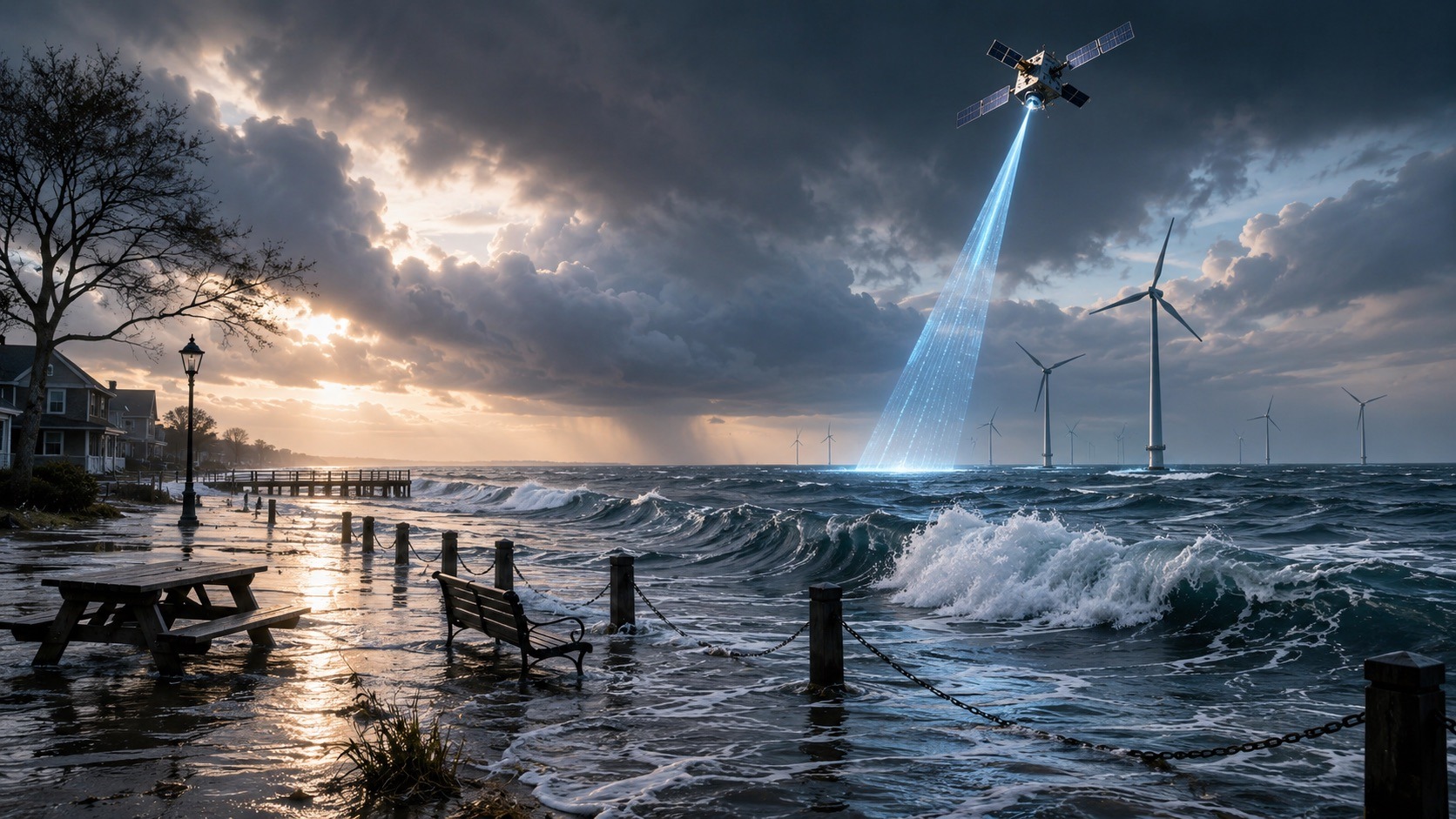


This is really a posting about sea level rise. However, to segue into it I will open with some recent news from Trump’s war on renewable energy. To be specific, this news as reported by various media outlets on June 17, 2026 …
Trump administration to pay $765M to cancel more offshore wind leases
This strategy by the Republican administration aims to impede offshore wind farm development
The Trump administration said it will buy back offshore wind leases for four more projects, pushing total spending on the agreements to nearly $2.6 billion….
… This strategy by the Republican administration aims to impede offshore wind farm development, which President Donald Trump opposes, while bolstering fossil fuel projects he supports…
Why would any administration spend public money to slow down one of the technologies needed to reduce emissions?
Because in practical terms, the Trump administration denies and rejects the mainstream reality of climate change. They may indeed oppose it politically, but the reality is that they are taking a stance against the laws of physics, and that’s not an argument you can ever win.
Trump has repeatedly framed climate concern as “climate alarmism,” called green policy a “scam,” and recently suggested climate research is “bogus.” FactCheck.org concluded that his recent claims misrepresented climate science and wrongly downplayed climate risks.
If you are reading this, then it is highly probable that you know that not only is climate change real, but also that we humans are causing it, and that it is perhaps the greatest risk our species has ever faced.
How can we actually know this?
If we live in a warming world, then sea level should not merely be rising; over time, the rate of rise should also be accelerating. If mainstream climate science were fundamentally wrong, then the global sea-level record should not show a persistent, accelerating rise consistent with a warming planet.
Let’s go there now.
Is Sea Level Rising?
This is actually quite a complex question.
A traditional way of measuring sea level rise has been through tide gauges. It sounds simple, just gather data of low and high tides from all around the coast, crunch the data and publish the results.
One small flaw, it is not at all that simple.
Why are Tide Gauges Challenging?
There are specific problems with taking readings from tide gauges at face value, and unless you consider these, then the readings you get do not tell you the real story.
Simplistic bathtub thinking just does not work.
Tide gauges are grounded on land. This means that they are affected by the vertical motion of the Earth’s crust, caused both by natural processes and human activities. Natural processes to consider would be a glacier melting and thus causing the land to rise, and also of course earthquakes. Human activities that have an impact include things such as groundwater depletion and dam building.
Rather obviously tide gauges are also local and not global. We don’t live on a disk world. We need to also remember that we live on a self-gravitating, viscoelastically compressible, rotating planet. In simple terms, sea level does not rise evenly everywhere.
It is also not just about melting ice.
If you heat water, then the additional kinetic energy of the water molecules increases. The molecules move more and so they maintain a greater average separation. In other words, as the ocean warms up the water in it will expand.
Sea level rise comes from both added meltwater and also thermal expansion. The balance varies by period, but both are major parts of the story.
So how reliable are the measurements we have, just how much confidence can we have in our current understanding of sea level rise?
We do, have a far more accurate global tool.
Since 1992, we have been using satellites to measure global sea level from orbit.
The first of many was on August 10, 1992 when TOPEX/Poseidon was launched. Since then, we have had a continuous and highly accurate record of continuous monitoring …
- TOPEX/Poseidon — launched 1992; the mission that began the modern precise global satellite sea-level record.
- Jason-1, Jason-2 / OSTM, Jason-3 — follow-on US/French/European missions that continued the same high-precision record.
- Sentinel-6 Michael Freilich — launched 2020; now the main reference mission for global sea-level measurement, continuing the TOPEX/Jason series.
- Sentinel-6B — the paired follow-on mission, intended to maintain continuity of the same record. Copernicus describes Sentinel-6 as the continuation of the sea-surface height record begun in 1992.
- ERS-1 / ERS-2, Envisat, CryoSat — ESA radar-altimetry missions that also contributed to sea-level and ocean-surface measurements, especially useful for continuity, regional studies, ice and coastal work.
- Sentinel-3A / 3B — European Copernicus satellites measuring sea-surface topography as part of broader ocean and land monitoring.
- SARAL/AltiKa — French/Indian altimetry mission often included in multi-mission sea-level products.
The basics are easy to grasp. As they orbit they send out continuous pulses of microwaves that then bounce off the ocean surface back up. These are then used to calculate the precise height of the sea surface. Getting that to work is of course complicated. You need to know exactly where the satellite is, and so the length of time for the radio pulse to arrive back enables the calculation of the exact height of the ocean surface.
Satellite data gives us a much clearer global picture, while tide gauges remain valuable for understanding local sea-level change.
Because this record now extends over more than three decades, scientists can see beyond seasonal, year-to-year, and even decade-scale variation.
What do we now know?
There are key insights …
- Sea level really is rising.
- The rate at which sea level is rising is accelerating
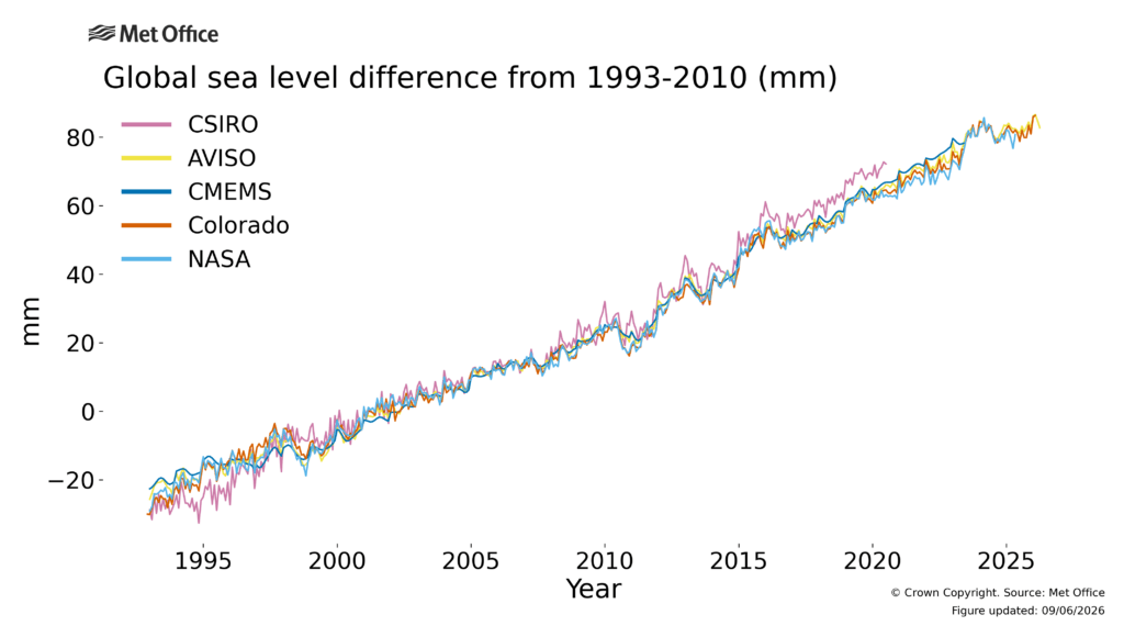
Via NASA we learn that the satellite-era rate rose from about 2.1 mm/year in 1993 to about 4.5 mm/year by 2024.
Even this is not simple. A single anomalous year can be higher. NASA reported 2024 at about 5.9 mm/year, but that is not the same as the smoothed current long-term rate.
Wait, hang on a moment, we are talking about millimeters here. That is tiny and it is also weird that we are using that unit of measurement.
Well yes. Firstly, the initiative to monitor and measure sea level rise is a global one that includes not only NASA but also other international bodies such as the European Space Agency, hence by convention they articulate measurements using millimetres, not inches.
It is still a very tiny number, so we don’t need to be too worried … right?
Sadly wrong, we really do need to be deeply concerned. 4.4-4.5 mm per year might indeed be tiny, but over the decades it adds up. Remember, the rate is also accelerating.
Here via the UK’s Met Office is a chart illustrating measurements from multiple independent sources …

What Comes Next?
The future projections are truly scary and also filled with choices. Via NASA we gain this insight …
If we are able to significantly reduce greenhouse gas emissions, U.S. sea level in 2100 is projected to be around 0.6 meters (2 feet) higher on average than it was in 2000.
On a pathway with high greenhouse gas emissions and rapid ice sheet collapse, models project that average sea level rise for the contiguous United States could be 2.2 meters (7.2 feet) by 2100 and 3.9 meters (13 feet) by 2150.
If policies such as Trump’s succeed in slowing the transition away from fossil fuels, then they push us closer to the more dangerous end of those projections.
Literally hundreds of millions of humans, perhaps closer to one billion, will be impacted.
Are we completely F**ked, is this a lost cause?
Short answer: No.
It is not just about the policy of the utterly corrupt and totally inept Trump administration. Instead, it is a global human issue, and so it needs a global human response.
For some it may feel like a lost cause and that we really are completely f**ked. However, we do still have choices.
The difference between 2 feet and 7.2 feet by 2100 is vast, and right now it is still a choice. One gives us a shot at having enough time to adapt, the other most probably does not.
Bottom Line: We Must Reduce Our CO₂ Emissions
Who you vote for matters. We need the right decision makers in place.
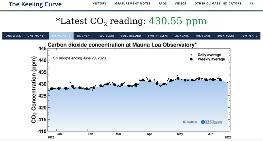
Let’s turn to one more chart, the Keeling Curve. We know how much CO2 we are pumping out and we can see where things currently stand.
This is the curve that we must bend downwards …

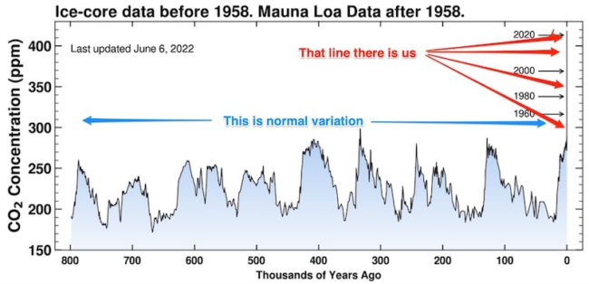
We can also view it over a far longer period – 800,000 years.
Snow falls in Antarctica, gets buried, and is slowly compressed into ice. As it compacts, tiny pockets of air are sealed inside. Those bubbles are actual samples of the atmosphere from the past, not just an indirect proxy. Scientists drill long cylinders of ice, release the trapped air in controlled lab conditions, and measure the CO₂ concentration in that air, usually reported in parts per million. NASA describes ice cores as the best source for this kind of historical climate data, with trapped gas bubbles revealing ancient greenhouse gas levels.
Here below is a chart that reveals the normal variation of CO2, and on the right is what we are doing …

How will it all play out?
I’d love to think that we will get this sorted. With sufficient political will we really could.
The problem is that I honestly don’t think the depth of political will needed is there. Instead we will fumble along, with some doing their very best and many others assuming that they don’t need to do anything because somebody else will get it all sorted out.
As things happen, we will respond in meaningful ways, but because we waited until something happened to spur us into action, we may end up finding we are already committed to a great deal of the consequences. The best we may achieve is to simply slow things down sufficiently to buy enough time to adapt.
I want to be wrong, I wish to be wrong, I hope to be wrong, I desire to be wrong. I’d honestly hope to be proven wrong.
Is it Really Possible to Make a Difference Now?
- Electric vehicles are here. Replacing many internal combustion engines can and should be accelerated. (No, I’m not an Elon fan, but there are plenty of other excellent options).
- Energy via solar, wind, nuclear, geothermal can give us all the power we need without buying fossil fuels
- Steel production accounts for about 7-8% of global emissions – green steel is viable.
- Sustainable aviation fuels are technically viable, though not yet available at anything like the scale needed.
- Rail CO2 capture is a fascinating idea
But all that costs $$$
True.
But so does doing none of it. The crux of the argument is that the cost of doing nothing will be greater than the cost of taking such steps.
Meanwhile as we dither, the sea level will continue to rise at an accelerating rate.
A Better World for Nothing
Let’s finish with Joel Pett’s now very famous 2009 cartoon …

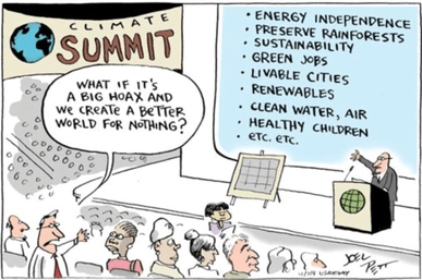
He is quoted as explaining …
“I’ve drawn 7,000 cartoons in my life, but really only one,” Pett said. “It’s an example of one of these ideas I had in my head for 10 years before I realized I hadn’t cartooned it…I was thinking, you know, ‘It doesn’t matter if global warming were a hoax, if the scientists made it up, we still have to do all that shit.’“
That is the point. Even if the deniers were right, the cleaner, healthier, more resilient world we would build in response would still be worth having. But the deniers are not right, and the sea is still rising.