Is the Northwest passage now open?
It has not been a commercially viable option, but because of climate change that is now changing. It was first reported on 27th August 2007 that the route was ice free and could be traversed without recourse to an icebreaker. That was the first time this was ever recorded (using records that go back as far as 1972). The following year it opened again on 25th August 2008.
It is of considerable commercial interest because being able to take this route cuts thousands of miles off the alternative.
So where do things stand right now?
NSIDC has access to, and publishes daily sea ice measurements via satellite. They report that right now it really is almost open …
Satellite passive microwave data and images from the Moderate Resolution Imaging Spectroradiometer (MODIS) suggest that the southern Northwest Passage routes are still open. While the passive microwave data show that the Northern Sea route is open, MODIS data reveal a narrow band of scattered sea ice blocking the passage near the Taymyr Peninsula.
So will we one day see cruise ships carrying passengers through the Northwest passage?
Actually yes, because that just happened. This year, for the first time ever by one, the cruise ship Crystal Serenity transited the Northwest passage with 1,700 passengers. The Washington Post reported on that and also that it cost upwards of $22,000 to be just one of those passengers. They advised …
The formerly remote Arctic is now open to summer cruise ships, and you can go along if you’re willing to pay.
Ice Free North Pole?
Not yet, but it is getting closer and was very close this season.
Closer look today at the North Pole shows even more polynyas and thinned sea ice (@NASANPP #VIIRS) pic.twitter.com/OizY1zHrHJ
— Zack Labe (@ZLabe) September 5, 2016
In the above you can clearly see that the area of broken ice and open water was very close to the North Pole. What Zack also points out is how temperatures are rising each and every year …
Unusually 'warm' year in the #Arctic (through August) and well exceeding previous records (NCEP since at least 1948) pic.twitter.com/biNoXYP0EB
— Zack Labe (@ZLabe) September 6, 2016
… and so clearly we are indeed marching rapidly down the road towards an ice free pole.
National Snow and Ice Data Centre update
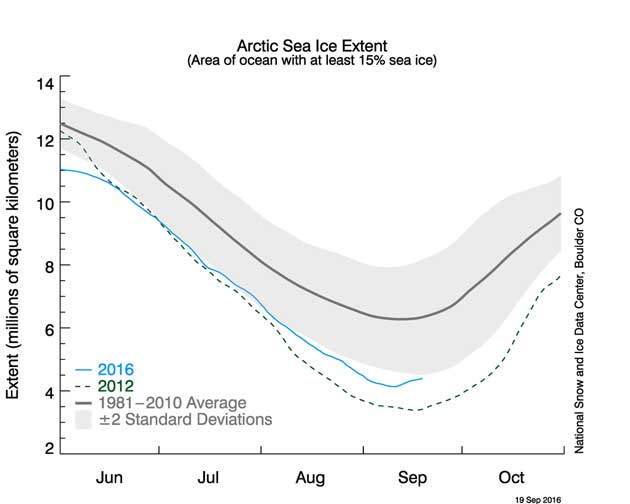
Here are a few notes that I’ve gleaned from the latest NSIDC update (dated 15th Sept) …
…Changing winds or late-season melt could still reduce the Arctic ice extent, as happened in 2005 and 2010. NSIDC scientists will release a full analysis of the Arctic melt season, and discuss the Antarctic winter sea ice growth, in early October….
… Weather in early September was warm along the Siberian coast (up to 9 degrees Celsius or 16 degrees Fahrenheit above average), with high pressure over the same region and strong winds across the central Arctic. However, as discussed in previous posts, weather over the Arctic Ocean this past summer has been generally stormy, cool, and cloudy—conditions that previous studies have shown to generally limit the rate of summer ice loss. That September ice extent nevertheless fell to second lowest in the satellite record is hence surprising….
Ten lowest minimum Arctic sea ice extents (1981 to 2010 average)
| RANK | YEAR | MINIMUM ICE EXTENT | DATE | |
|---|---|---|---|---|
| IN MILLIONS OF SQUARE KILOMETERS | IN MILLIONS OF SQUARE MILES | |||
| 1 | 2012 | 3.39 | 1.31 | Sept. 17 |
| 2 | 20162007 | 4.144.15 | 1.601.60 | Sept. 10Sept. 18 |
| 3 | 2011 | 4.34 | 1.67 | Sept. 11 |
| 4 | 2015 | 4.43 | 1.71 | Sept. 9 |
| 5 | 2008 | 4.59 | 1.77 | Sept. 20 |
| 6 | 2010 | 4.62 | 1.78 | Sept. 21 |
| 7 | 2014 | 5.03 | 1.94 | Sept. 17 |
| 8 | 2013 | 5.06 | 1.95 | Sept. 13 |
| 9 | 2009 | 5.12 | 1.98 | Sept. 13 |
| 10 | 2005 | 5.32 | 2.05 | Sept. 22 |
Looking back to when such measurements were first calculated (1980), the top ten record breaking years with the lowest extent of sea ice have all been more or less (apart from 2006) the last 10 years.
Mote #Arctic Tweets
#Arctic sea ice 13 September 2016 verses Arctic sea ice 13 September 1985 (random date choice) pic.twitter.com/vPC1EbQqYY
— Mark Brandon (@icey_mark) September 15, 2016
#Arctic Ice Shrinks to 2nd Lowest Level on Record https://t.co/7DKGTrpuWr via @AP @DoctorFluxx @seth_leitman @coolmyplanet @skookerG pic.twitter.com/peqb1P1Old
— Allan Margolin (@AllanMargolin) September 20, 2016
